F11 SOP
Table of Updates
| Date | Revision | Items Revised |
|---|---|---|
| 9 September 2023 | A | STAR Arriving Procedures for GOOFY#, JOKRS#, MINEE# via revised LOA with ZMA. DADES# HIBAC Arrival Procedures. |
| 18 September 2023 | B | Update of Primary Departure, Arrival, and Satellite Frequencies |
| 10 October 2023 | C | No Radar Handoffs to Twr |
Area Information
| ICAO Code | Airport Name | Airspace | IFR Beacon Codes | VFR Beacon Codes |
|---|---|---|---|---|
| F11 | Central Florida Tracon |
Purpose:
This document prescribes the procedures to be utilized for providing air traffic control services at the Central Florida Tracon. The procedures described herein are supplemental to the Jacksonville ARTCC Facility Operating Guidelines and FAA Order JO 7110.65, as well as any published FAA guidelines or procedures.
Distribution:
This order is distributed to all Jacksonville ARTCC personnel.
Operational Positions
| Position | Sector Name | Callsign | Relief Callsign | Symbol | Frequency |
|---|---|---|---|---|---|
| DRE | Departure Radar East | MCO_E_DEP | MCO_1E_DEP | 4E | 124.800 |
| DRW | Departure Radar West | MCO_W_DEP | MCO_1W_DEP | 4W | 120.150 |
| ARB | Arrival Radar Bitho | MCO_B_APP | MCO_1B_APP | 4B | 128.375 |
| ARL | Arrival Radar Leese | MCO_L_APP | MCO_1L_APP | 4L | 134.050 |
| ARG | Arrival Radar Goofy | MCO_G_APP | MCO_1G_APP | 4G | 127.750 |
| ARM | Arrival Radar Minee | MCO_M_APP | MCO_1M_APP | 4M | 123.850 |
| SRD | Satellite Radar Disney | MCO_D_APP | MCO_1D_APP | 4D | 119.400 |
| SRK | Satellite Radar Kape | MCO_K_APP | MCO_1K_APP | 4K | 134.950 |
| SRN | Satellite Radar North | MCO_N_APP | MCO_1N_APP | 4N | 121.100 |
| SRS | Satellite Radar South | MCO_S_APP | MCO_1S_APP | 4S | 132.650 |
| SRV | Satellite Radar Ovido | MCO_V_APP | MCO_4V_APP | 4V | 119.775 |
| SRP | Satellite Radar Paola | MCO_P_APP | MCO_1P_APP | 4P | 135.300 |
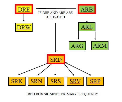
Sector in Red is the primary sector.
Sectorization Flow Chart
Description:
1. The primary arrival, departure, and satellite "combined" radar position shall be ARB.
2. The primary departure only radar position shall be DRE. DRE may not be activated without ARB being activated.
3. The primary satellite only radar position shall be SRD. SRD shall not be activated until ARB and DRE are activated.
General Information
Handoffs: F11 shall not complete any a radar handoff for arriving aircraft to tower. All other internal and external handoffs shall be initiated as soon as the aircraft are clear of conflict.
VFR Aircraft: VFR Aircraft within the Orlando Class Bravo airspace shall ordinarily be kept below 5,000 feet and within the appropriate satellite radar position.
Departure Release: Unless otherwise coordinated, F11 shall give automatic departure releases to all traffic from MCO. All other airports within F11 shall request a departure release for traffic receiving radar services. Upon receipt of the departure release, the release shall remain valid for five (5) consecutive minutes. Upon issuance of the takeoff clearance, a rolling call notification message shall be sent to the appropriate F11 radar controller. This notification should include the callsign of the aircraft and the departure runway the aircraft is departing from.
Rolling Calls:MCO ATCT will ensure datatag auto acquires and will not send rolling calls to F11 departure controllers unless one of the following criteria is met:
a. The F11 departure controller requests rolling calls.
b. The departure scratchpads are not completed as per Chapter 7.1 of this SOP.
c. The departing aircraft is issued a departure heading not outlined in the MCO ATCT Standard Operating Procedures.
Runway Change Procedures: When changing runways, LC must verbally coordinate with the appropriate F11 position(s) for the last departure/arrival off the previously used runway and the first departure/arrival off the newly selected active runway(s). Notify F11 of the new runway configuration and last departure and arrivals. When notified by F11, stop all departures on the present configuration. When F11 is ready for the new configuration, F11 will notify LC. Upon completion of notification, departures may resume with the new configuration. Ensure ATIS has been updated to reflect the new configuration.
Simultaneous Approaches: Runway 36L/36R and Runway 18R/18L may not be used for simultaneous instrument approaches. The ATIS shall indicate at all times “Caution simultaneous approaches in use” prior to stating the arrival runways.
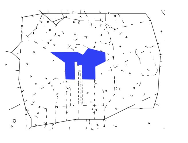
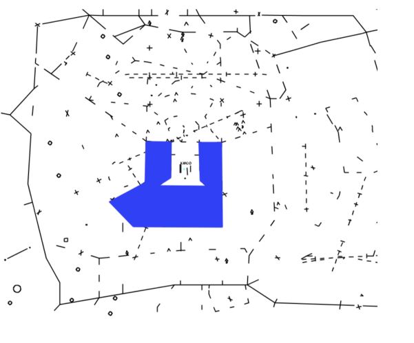
Special Use Airspace: The following areas are designated special use airspace under the jurisdiction of the F11 TRACON. R-2901B, E, M (by LOA with ZMA, SFC-FL180), R-2932, R-2933, R-2934, R-2935, R-2910B and C, Disney World TFR (SFC-3,000ft until further notice).
Approach Scratchpads: F11 uses a three letter format consisting of XYY where X identifies the type of approach and YY consists of the runway truncated to two characters. For example, Runway 18R would be 8R. Therefore, an ILS approach to Runway 18R would be represented by I8R.
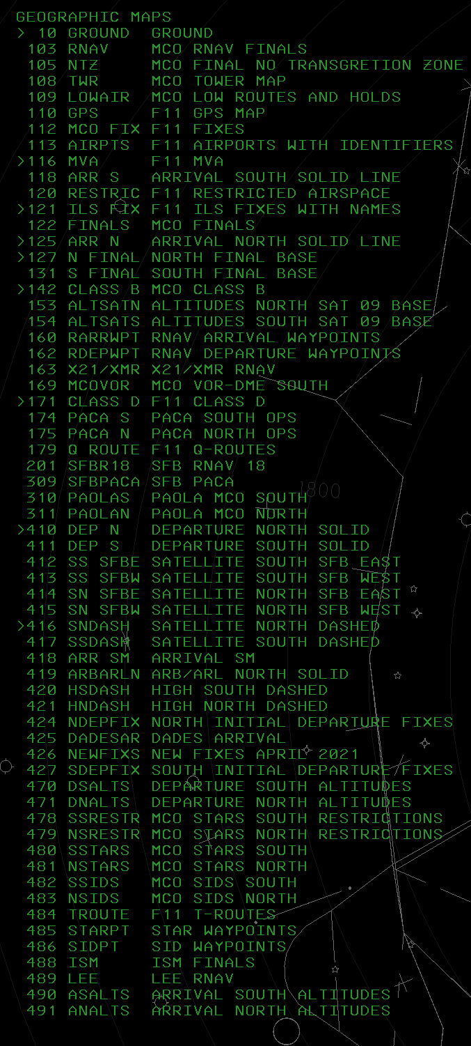
STARS Map List:
Departure Radar
In-trail spacing
Radar positions shall ensure aircraft have at least five nautical mile in-trail spacing, constant or increasing, when exiting the F11 airspace.
Missed Approach Procedure
All aircraft will be instructed to climb to 3000 feet. Aircraft landing the west complex will be turned heading 270 and transferred to ARM (DRW if combined). Aircraft landing the east complex will be turned heading 090 and transferred to ARG (DRE if combined). Do not assign the published missed approach for IFR aircraft unless the pilot requests it and traffic allows, or it's requested by the F11 radar sectors. Radar handoff, controller coordination and voice handoffs should be initiated as soon as practical to the appropriate final controller.
Pre-arranged Coordination Procedures
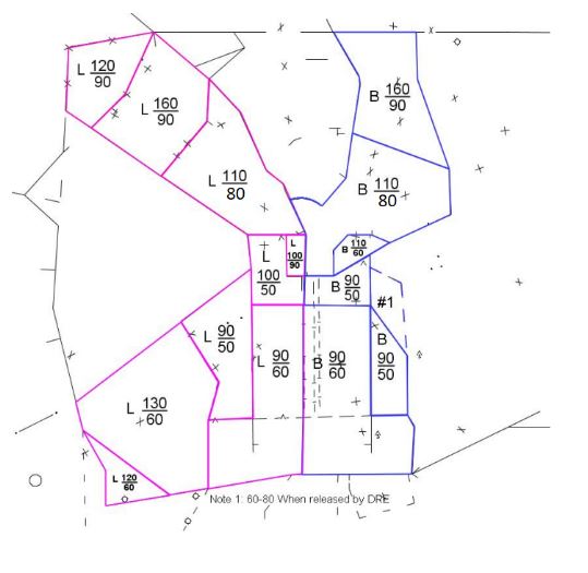
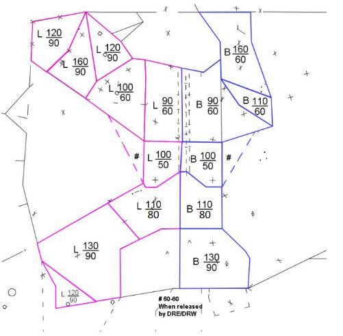
1. MCO departures operating under the jurisdiction of either DRE or DRW (DR) may penetrate the depicted (see sections 3.10 and 3.11) ARL or ARB (Feeder) airspace without a pointout.
2. While utilizing PACP, DR must “quicklook” ARL and ARB sectors or otherwise display the full data block of aircraft under Feeder control.
3. DR is responsible for maintaining separation from AR aircraft and must not interfere with normal AR operations.
4. DR may climb, but not level aircraft within AR airspace.
5. DR must not utilize visual separation with AR aircraft without prior coordination with AR.
6. AR reserves the right to temporarily cancel the procedures outlined in this section for any reason.
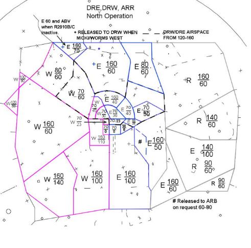
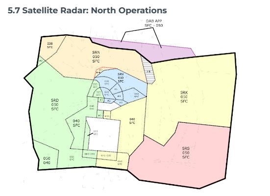
North Operations
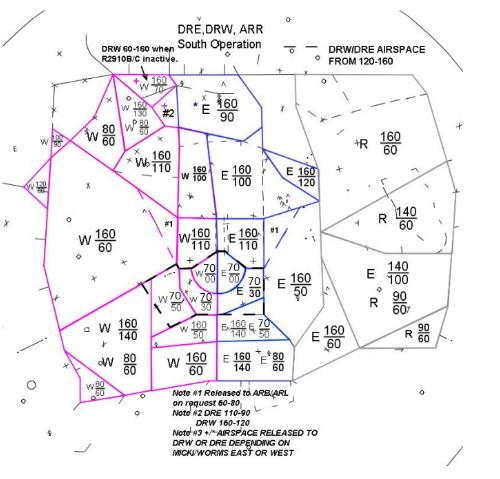
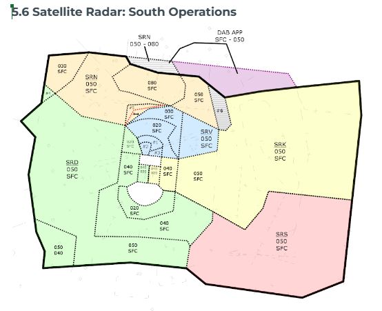
South Operations
Responsibility
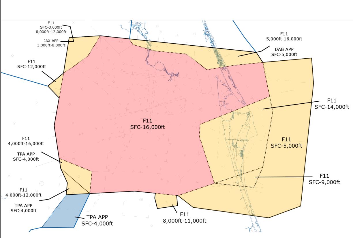
Provide approach control services within the airspace depicted
Departures
| Departure | Operations | Vector Point | Climbing Restrictions | Handing off to |
|---|---|---|---|---|
| CITR# | All Ops | DTA. | Variable | Variable |
| Daytona Arrivals | All Ops (Piston Aircraft Only) | DTA | 6,000 | |
| DDANY# | North Ops | Climb via SID except maintain 14,000. | MIA_CTR | |
| South Ops | UKAYY | 14,000 | ||
| FATHE# | North Ops | Climb via SID except maintain 16,000. | JAX_57_CTR | |
| South Ops | BUFFI | 16,000 | ||
| Jacksonville Arrivals | All Ops (Piston Aircraft Only) | DTA | 10,000 | |
| MZULO# | North Ops | Climb via SID except maintain 14,000. | MIA_CTR | |
| South Ops | GERCK | 14,000 | ||
| ORLA# | All Ops | DTA. | Variable | Variable |
| All Other | DTA. | Variable | Variable |
Aircraft Not on the RNAV SID shall not be climbed above 7,000 feet until clear of arrival corridor and arrival radar sectors.
Jet and Turboprop aircraft departing KMLB and KCOF Airports which are Southeast bound may be cleared direct TRV, in accordance with the ZJX/ZMA LOA.
Arrivals
| Arrival Airport(s) | Transition | Crossing Point | Altitude Restriction | Speed Restriction | Handing off to |
|---|---|---|---|---|---|
| MCO | ALYNA.SURFR | SURFR 14000 | Descend VIA | ARB | |
| TPA | DADES# STAR | Border of DRE/DRW | 16,000 Feet | DRW | |
| TIX, TTS, XMR, COI, X21, and 21FA | Border of DRE/SRK | 6,000 Feet | SRK | ||
| MLB, COF, and X59 | Border of DRE/SRS | 6,000 Feet | SRS |
Responsibility
Provide approach control services within the airspace depicted
Unless established on an RNAV SID, vector IFR departures to the appropriate DTA. Aircraft on the ORLA# and CITR# departure shall not be climbed above 7,000 feet until clear of the arrival corridor and arrival radar sectors.
Departures
| Departure | Operations | Vector Point | Climbing Restrictions | Handing off to |
|---|---|---|---|---|
| CITR# | All Ops | DTA. | Variable | Variable |
| Daytona Arrivals | All Ops | DTA | 6,000 | |
| FSHUN# | North Ops | Climb via SID except maintain 16,000. | MIA_CTR | |
| South Ops | TUPPY | 16,000 | ||
| Jacksonville Arrivals | All Ops (Piston Aircraft Only) | DTA | 10,000 | |
| JEEMY# | North Ops | Climb via SID except maintain 16,000. | JAX_57_CTR | |
| South Ops | MDUSA | 16,000 | ||
| ORLA# | All Ops | DTA. | Variable | Variable |
| OSPRY# | North Ops | Climb via SID except maintain 16,000. | JAX_15_CTR | |
| South Ops | OSPRY | 16,000 | ||
| RDSOX# | North Ops | Climb via SID except maintain 16,000. | JAX_15_CTR | |
| South Ops | RDSOX | 16,000 | ||
| All Other | DTA. | Variable | Variable |
Arrivals
| Arrival Airport(s) | Transition | Crossing Point | Altitude Restriction | Speed Restriction | Handing off to |
|---|---|---|---|---|---|
| TPA | DADES# via HIBAC | GUURR | North at 12,000, South at 10,000 and 250 Kts. | TPA_APP |
Aircraft Not on the RNAV SID shall not be climbed above 7,000 feet until clear of arrival corridor and arrival radar sectors.
Aircraft inbound to the TPA ATCT not an a STAR into TPA area shall exit F11 at or below 12,000 feet and be vectored through the KNEED DTA. CAMDT shall not be used for TPA arrivals unless on the DADES/LZARD STARs.
</tab>
Arrival Radar
| STAR | Transition | Receiving From | Operations | Crossing Point | Altitude Restriction | Speed Restriction | NOTE | Handing off to |
|---|---|---|---|---|---|---|---|---|
| ALYNA# | GRDON/WOPNR | JAX_57_CTR TIMIE at 12,000. South Ops: 250 Kts | North Ops | F11 shall instruct aircraft to Descend via the Arrival with Runway Assignment. | ARG | |||
| South Ops | F11 shall instruct aircraft to Descend via the Arrival with Runway Assignment. | ARG | ||||||
| BITHO# | OMN | JAX_57_CTR LAMMA at 12,000. South Ops: 250 Kts | North ops | BITHO | 8,000 | After BITHO Vector Towards a downwind to the airport, Descend to 5,000. | ARG | |
| South Ops | Upon Receipt of Aircraft | 6,000 | Vector Towards a base leg | ARG | ||||
| GTOUT (Get Out) | LPERD | JAX_57_CTR Descending via | North ops | N/A | ||||
| South Ops | Aircraft will cross BANYA at 6,000. | ARG | ||||||
| GOOFY# | MIA_CTR at BAIRN: North Ops @ 11,000, South Ops @ 8,000. Satelittes @ 8,000. | North ops | Upon Receipt of Aircraft | 6,000 | After BAIRN Vector Towards a downwind to the airport. | ARG | ||
| South Ops | Upon Receipt Parallel the field |
8,000 5,000 |
After ODDEL vector for a downwind. | ARG | ||||
| RIDES# | MIA_CTR Descend via | North ops | Aircraft will cross HAHNA at 6,000 | ARG | ||||
| South Ops | Aircraft will cross PTMAN at 5,000 | ARG | ||||||
| SNFLD (Sinfeld) | LPERD | JAX_57_CTR Descending via | North Ops | Aircraft will cross CUBAL at 5,000. | ARG | |||
| South ops | N/A | |||||||
| STAR | Transition | Receiving From | Operations | Crossing Point | Altitude Restriction | Speed Restriction | NOTE | Handing off to |
|---|---|---|---|---|---|---|---|---|
| GRNCH#/JAFAR# | JAX_15_CTR Descend via | North Ops | Aircraft will cross BRICE at 5,000. | ARM | ||||
| South Ops | Aircraft will cross YAGGO at 6,000. | ARM | ||||||
| JOKRS# | MIA_CTR at MOANS: JET at 13,000 TP at 10,000 Piston at 5,000 |
North Ops | F11 shall instruct aircraft to Descend via the Arrival with Runway Assignment. | ARM | ||||
| South Ops | F11 shall instruct aircraft to Descend via the Arrival with Runway Assignment. | ARM | ||||||
| LEESE | JAX_15_CTR via SHIMM at 11,000 | North Ops | Descend to 8000 then enter a downwind for the runway and descend to 5,000. | ARM | ||||
| South Ops | Descend to 6,000. | ARM | ||||||
| MINEE | MIA_CTR at MOANS or ANDRO Jets at 13,000 TP at 10,000 Pistons at 5,000 |
North OPS | After MINEE vector to a base and descend to 5,000. | ARM | ||||
| South Ops | After UNITY vector to a downwind and descend to 5,000. | ARM | ||||||
| PRICY# | MIA_CTR Descend via | North Ops | Aircraft will cross LORRA at 7,000. | ARM | ||||
| South Ops | Aircraft will cross LYENS at 5,000. | ARM |
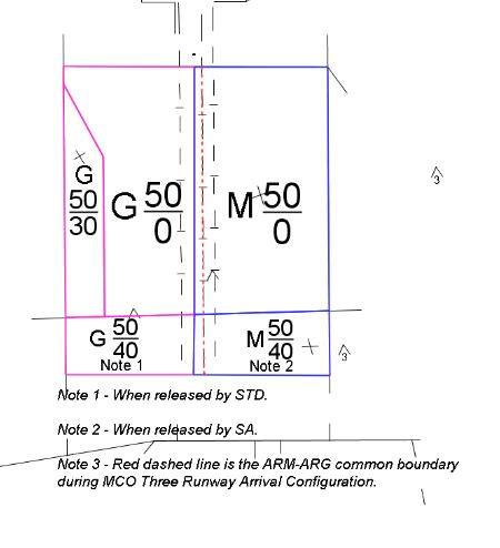
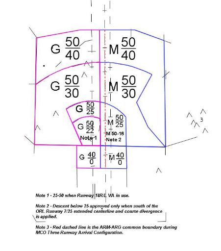
All aircraft shall be handed off to facilitate further descent. Radar handoffs to ARM/ARG shall be completed no later than aircraft crossing the ARM/ARG boundary. ARM/ARG shall issue a descent to no lower than 4,000 feet in south operations or 3000 feet in north operations and vector aircraft towards the final approach course. Arrivals should be kept at or above 4000 feet to remain above the SFB Class C Airspace.
If the aircraft is on a visual approach, aircraft can be instructed to, “Join the localizer…” for their respective runway. Further descent may be issued to aircraft having difficulty obtaining the airport visually:
MCO South Operations - 2,500 feet: Aircraft should maintain 2500 until south of KORL, ORL VOR or TUFFE, GLOSI or SEEDO on the localizers.
MCO North Operations - 1,600 feet
During periods of IMC conditions, simultaneous parallel instrument approaches to the outer runways may be executed without diagonal separation. These runways are separated by more than 12000 feet. Ensure aircraft are separated by 3 NM or 1000 ft at turn on.
Once aircraft have received an approach clearance, a radar handoff to MCO ATCT shall be initiated. Once the handoff is completed, aircraft communications shall be transferred to the MCO ATCT.
Extreme caution should be exercised during MCO south operations due to inbound and outbound traffic at ORL. Aircraft inbound or outbound to ORL are below MCO inbound traffic and with SRV/SRD controllers.
Satellite Radar
Satellite radar airspace extends from the surface to 5,000 feet. Satellite radar’s primary function is to sequence inbound and outbound traffic to satellite airports. Aircraft inbound to any airport other than MCO within F11 airspace will eventually be under the jurisdiction of a satellite radar position, prior to landing.
ARL and ARB shall provide satellite bound aircraft appropriate initial vectors and will descend to 6000 feet.
For arrivals into satellite airports: Once aircraft have received an approach clearance, a pointout to the appropriate ATCT shall be initiated. Once the pointout is completed, aircraft communications shall be transferred to the ATCT.
Sanford ATCT
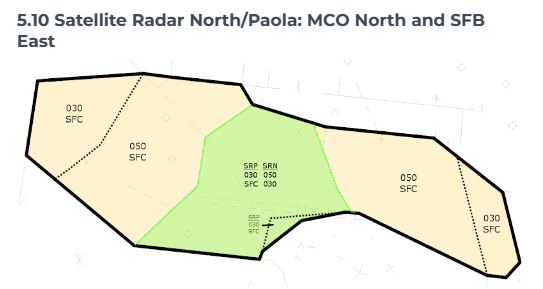
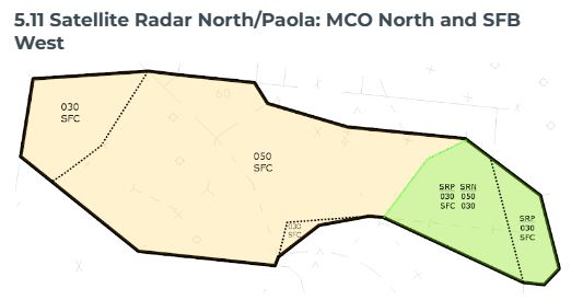
Departures: Aircraft departing SFB shall turn in accordance with their assigned heading. Upon identification, aircraft shall be climbed to 5,000 feet and a headoff inititated with the appropriate departure radar. SFB northbound departures shall receive an immediate turn towards the WORMS DTA. SFB Airport departures exiting F11 via the WORMS DTA shall cross the F11 TRACON Boundary into DAB at or below 11,000. SRN shall send the aircraft to DAB APP or JAX_CTR. SRN will provide positive separation with aircraft in DRE airspace and DRE will provide automatic pointout with SRN for this outbound traffic.
Note: KSFB utilizes a Terminal VFR Arrival Route. Jessup and Monroe Arrival. Pilots familiar with this may request this procedure. Please see Monroe/Jessup VFR Arrival in the SFB ATCT SOP,
Daytona ATCT
DAB Arrivals: Aircraft inbound to the DAB ATCT area shall be established northbound on V267 prior to initiating a handoff to the DAB ATCT. Aircraft NOT established on V267 shall be cleared direct KIZER and instructed to join V267.
Tampa ATCT
TPA Arrivals: Aircraft inbound to the TPA ATCT area shall be vectored through the KNEED DTA on a heading of 250.
